


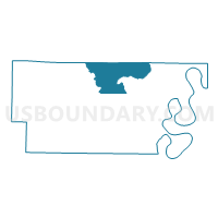
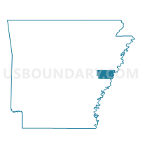
Union Voting District, Lee County, Arkansas
About
Outline

Summary
| Unique Area Identifier | 527071 |
| Name | Union Voting District |
| County | Lee County |
| State | Arkansas |
| Area (square miles) | 48.31 |
| Land Area (square miles) | 47.85 |
| Water Area (square miles) | 0.46 |
| % of Land Area | 99.05 |
| % of Water Area | 0.95 |
| Latitude of the Internal Point | 34.86658020 |
| Longtitude of the Internal Point | -90.74049580 |
Maps

Graphs
Select a template below for downloading or customizing gragh for Union Voting District, Lee County, Arkansas


Neighbors
Neighoring Voting District (by Name) Neighboring Voting District on the Map
- BONAIR PCT 17, St. Francis County, AR
- Independence Voting District, Lee County, AR
- Liberty Voting District, Lee County, AR
- MADISON COUNTRY PCT 15, St. Francis County, AR
- PALESTINE COUNTRY PCT 31, St. Francis County, AR
- RAWLINSON PCT 5, St. Francis County, AR
- St. Francis Voting District, Lee County, AR
- Texas Voting District, Lee County, AR
- TUNI PCT 16, St. Francis County, AR
Top 10 Neighboring County Subdivision (by Population) Neighboring County Subdivision on the Map
- Independence township, Lee County, AR (5,266)
- St. Francis township, Lee County, AR (1,882)
- Prairie township, St. Francis County, AR (1,197)
- Franks township, St. Francis County, AR (922)
- Texas township, Lee County, AR (383)
- Union township, Lee County, AR (274)
- Black Fish township, St. Francis County, AR (111)
Top 10 Neighboring Place (by Population) Neighboring Place on the Map
Top 10 Neighboring Unified School District (by Population) Neighboring Unified School District on the Map
- Forrest City School District, AR (23,630)
- Lee County School District, AR (10,424)
- Hughes School District, AR (3,154)
- Palestine-Wheatley School District, AR (2,340)
Top 10 Neighboring State Legislative District Lower Chamber (by Population) Neighboring State Legislative District Lower Chamber on the Map
Top 10 Neighboring State Legislative District Upper Chamber (by Population) Neighboring State Legislative District Upper Chamber on the Map
Top 10 Neighboring 111th Congressional District (by Population) Neighboring 111th Congressional District on the Map
Top 10 Neighboring Census Tract (by Population) Neighboring Census Tract on the Map
- Census Tract 9602, St. Francis County, AR (6,372)
- Census Tract 4703, Lee County, AR (4,303)
- Census Tract 9601, St. Francis County, AR (3,136)
- Census Tract 4701, Lee County, AR (2,845)
- Census Tract 9603, St. Francis County, AR (2,700)
- Census Tract 4702, Lee County, AR (1,713)